


Arctic Sea Ice Loss: Spectacular And Ominous
By Neven Acropolis
14 February, 2012
Thinkprogress.org
Has the melt season started in the Barents and Kara Seas two months earlier than normal?
We are entering the final stage of the freezing season in the Arctic. Winter time is usually a boring time for watching the sea ice. Due to the polar night there are no direct satellite images, and it’s hard to tell what’s exactly going on up there because the ice is simply everywhere, filling up the entire Arctic ocean.
This winter was looking more or less like previous years, until about a month ago. A flip in atmospheric patterns that brought very late winter conditions to Europe, also had an effect on the fringes of the ice pack on the Atlantic side of the Arctic. Large swathes of sea water in the Barents and Kara Seas that ought to have been completely frozen over, opened up and total Arctic ice growth came to a practical standstill on various graphs, such as the Cryosphere Today sea ice area graph.
The regional effect can clearly be seen on this comparison of sea ice concentration maps for February 11th in the 2004-2012 period:
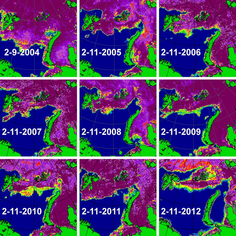
Image courtesy of the University of Bremen
Novaya Zemlya, the large Russian island that divides the Barents and Kara seas, is completely ice-free. The same almost goes for Svalbard, the archipelago in the top left. I think it’s safe to safe that this is unprecedented ever since satellites started monitoring Arctic sea ice in 1979. I have been looking at the Arctic sea ice from up close for about two years now, but this is definitely one of the most spectacular things I have seen so far. It’s almost as if the melting season has already started in the Barents and Kara Seas, more than two months earlier than normal.
What could be causing such an early retreat of sea ice cover?
First and foremost was a big high-pressure system over northern Russia that formed a little over two weeks ago and swept the Siberian cold towards Europe. At the same time this high drew in winds from the west, pushing the ice back in the Barentsz and Kara Seas. These winds also brought warm air and rain from the North Atlantic. Take for instance this data from the weather station at Svalbard for the latest 30 days:
Average temperature was -2.4 °C, 13.4 °C above the normal. Highest temperature was 7.0 °C (08 February), and the lowest was -15.0 °C (25 January). The total precipitation was 79.5 mm.
So warm winds, warm rain. How about the water? The winds were probably taking the warm waters from the North Atlantic Current some further still into the Arctic, to places where the sea water never really cooled down enough after last year’s melting season (more on that below) for some proper ice formation, as can be seen on this sea surface temperature anomaly map from the Danish Meteorological Institute:

As spectacular as the retreat has been, the impact on sea ice area and extent numbers was cushioned by above average ice growth on the Pacific side of the Arctic, in the Bering Sea, where ice has been expanding far into the Pacific (more on this in the latest blog post on the Arctic Sea Ice blog). Nevertheless, there is a distinct possibility that 2012 will have the lowest maximum winter ice cover in various data sets. It depends on what happens in these final 4-6 weeks.
For now the weather has turned yet again and conditions in the Barents and Kara Seas are returning to ‘normal’, meaning freezing temperatures that will probably re-cover part of the open water with thin ice. How much of a late freeze-up in the Barents and Kara Seas there will be, remains to be seen. As was mentioned above it’s not just determined by the weather, but also by the sea surface temperatures. This is what the SST anomaly looked like from last year’s minimum to the start of this year (based on data from the NOAA ESRL Physical Science Division):
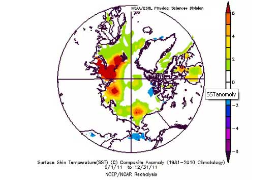
The anomaly in the Barents and Kara Sea regions as this year is the largest on record. Nothing that happens in this final stage of the freezing season will change much about that. Under the right circumstances the Sun could melt the ice in record time in these western Siberian seas, which in turn would have cascading effects for the rest of the melting season. As was reported here on ClimateProgress and elsewhere last week, there could be a link between ice cover and sea surface temperature in this region and subsequent winter weather in Europe. If things keep moving in this direction, we will find out very quickly whether the theory has merit or not. As things currently stand, the Atlantic side of the Arctic looks spectacular. Spectacular and ominous.
Neven Acropolis of the must-read Arctic Sea Ice Blog
Comments are not moderated. Please be responsible and civil in your postings and stay within the topic discussed in the article too. If you find inappropriate comments, just Flag (Report) them and they will move into moderation que.